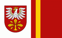
Dąbrowa County (powiat dąbrowski) is a unit of territorial administration and local government (powiat) in Lesser Poland Voivodeship, southern Poland. It was created on 1 January 1999 as a result of the Polish local government reforms passed in 1998. Its administrative seat is the town of Dąbrowa Tarnowska, which lies 76 km east of the regional capital Kraków. Its only other town is Szczucin, lying 16 km north of Dąbrowa Tarnowska.
The county covers an area of 530.0 km2. As of 2019 its total population is 59,227, out of which the population of Dąbrowa Tarnowska is 11,889, that of Szczucin is 4,157, and the rural population is 43,181.
Dąbrowa County is bordered by Busko County and Staszów County to the north, Mielec County and Dębica County to the east, Tarnów County to the south, and Kazimierza County to the west.